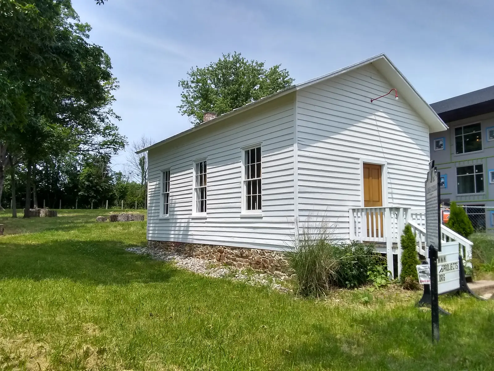
Ashburn was Farmwell until 1896, when the post office took the name of Sen. William Stewart's Ashburn farm. Four National Register sites stand in and around it.
Last checked Oct. 18, 2026. Sources: historian Eugene Scheel’s history of Ashburn on loudounhistory.org; the National Park Service’s National Register of Historic Places listings (May 22, 2026, file); and Loudoun Now on the Ashburn Colored School. Ashburn has no city history office; Loudoun County is its government.
Ashburn has never been an incorporated town, so it has no founding charter. It grew from colonial land grants into a railroad and dairy village, then, from the 1980s, into what Scheel calls the county’s most populous unincorporated area.
Visiting
- Most landmarks below are private property, a working campus or an active church; view them from public roads.
- Loudoun County historic preservation questions: Planning and Zoning, 703-777-0246
- More county history: the Loudoun County Historic and Heritage Resources page
From Lee land to Farmwell
The Ashburn area began as part of 11,182 acres granted to Thomas Lee from 1719 to 1728, according to Scheel; Leesburg later took his name. A century on, Lee’s descendants held about 4,700 acres in four parts: Coton (now Lansdowne), north of today’s Route 7; Belmont, south of Route 7; Farmwell, east and south of Belmont; and the Forest Tract, west and south of Belmont.
The name Farmwell first appears in George Lee’s will of October 1802, describing his plantation. In 1849 the Lees gave land for a combined log church and school, built in 1853 near today’s Shellhorn and Ashburn roads, and the village that grew there took the Farmwell name. That spot is now called Ryan.
The railroad and the name Ashburn
In January 1860, the Alexandria, Loudoun and Hampshire Railroad, the line that is now the W&OD Trail, opened a depot at Ashburn Road. The post office there became Farmwell, and the older settlement became Old Farmwell. The railroad built the dairy business: Farmwell Station was 45 minutes by train from Washington, so morning milk in ice-cooled cars reached the city fresh, Scheel writes.
The Ashburn name came from the Forest Tract, owned by lawyer and politician John Janney, who presided over Virginia’s 1861 secession convention. Its eastern section became known as Ashburn after the Civil War; the first recorded use, about 1870, described Janney’s farm. Local legend says a huge ash tree near the house burned for days after a lightning strike.
Nevada Sen. William Morris Stewart, the “Silver Senator,” bought Ashburn plantation in 1895 and ran it as a large dairy. In 1896, Stewart argued that handwritten “Farmwell” was too easily confused with the Farmville post office in Prince Edward County, and the village was renamed Ashburn after his farm. Janney’s T-shaped summer house, also called Ashburn, was bulldozed in 1987; its site is in the middle of today’s Ashburn Park.
National Register of Historic Places
The National Park Service lists these places in and at the edge of Ashburn:
| Property | Location in the NPS record | Listed |
|---|---|---|
| Broad Run Bridge and Tollhouse | Junction of Routes 7 and 28 at Broad Run, Ashburn-Sterling line | April 17, 1970 |
| Belmont | 1.8 miles north of Ashburn | Feb. 8, 1980 |
| Janelia | North side of Route 7, 6 miles east of Leesburg | March 20, 1987 |
| Ashburn Presbyterian Church | 20962 Ashburn Road | Aug. 5, 1999 |
Each link opens the nomination file at the National Archives, with the history and architecture of the site.
The Ashburn Colored School
On Ashburn Road in Old Ashburn stands the Ashburn Colored School, a one-room schoolhouse that educated Black children in Loudoun before desegregation. It had no heat or running water and stood empty from the late 1950s. The Loudoun School for the Gifted bought the property in 2014 to make it a living museum. After vandals spray-painted swastikas and hateful messages on it overnight on Sept. 30, 2016, community donations completed the restoration, and the renewed school was unveiled to the public on Sept. 16, 2017, with former students present, Loudoun Now reported.
Old Ashburn today
The railroad depot stood at Ashburn Road, where the W&OD Trail now crosses. Along Ashburn Road today are Ashburn Presbyterian Church, at 20962, and the Ashburn Volunteer Fire and Rescue Department’s Station 6, at 20688. Walk or bike in on the W&OD; see our parks and trails guide.
What this means for you
Much of Ashburn’s farm past is gone; Scheel notes that no place name in the area today honors Janney or the Lees, even though Ashburn and Farmwell came from their lands. For how the place has grown since, see Ashburn population and growth.
Frequently asked questions
How did Ashburn, Virginia get its name?
From Ashburn Farm, a plantation once owned by John Janney. In 1896 the Farmwell post office was renamed Ashburn, to match the farm then owned by Nevada Sen. William Morris Stewart, because Farmwell was too easily confused with Farmville.
What was Ashburn called before?
Farmwell, or Farmwell Station, after George Lee’s plantation. The name first appeared in Lee’s 1802 will.
Is Ashburn an incorporated town?
No. Ashburn has never been incorporated; it is an unincorporated community governed by Loudoun County.
What National Register of Historic Places sites are in Ashburn?
Belmont (listed 1980), Janelia (1987) and Ashburn Presbyterian Church (1999), plus the Broad Run Bridge and Tollhouse (1970) at Route 7 and Route 28 on the Ashburn-Sterling line.
Have your say