Ashburn Farm, in ZIP 20147, is zoned for Trailside Middle and Stone Bridge High. Zillow's typical 20147 value was $746,114 in September 2026.
Last checked Oct. 19, 2026. The boundary and home counts are Loudoun County’s Residential Communities layer (counts as of July 1, 2025); school zones are the county’s 2026-27 elementary, middle and high school zone layers, counted over the county’s address points; ratings are the Virginia Department of Education’s School Quality Profiles; home values are the Zillow Home Value Index (Zillow Research); buses are Loudoun County Transit’s GTFS feed (Sept. 27, 2026); parks, stores and road distances come from OpenStreetMap (© OpenStreetMap contributors) and county park pages.
Ashburn Farm is a 1,173-acre planned community in the middle of Ashburn, between Belmont Ridge Road and Ashburn Village, with the Dulles Greenway along its southern edge. Loudoun County lists it as a completed community of 3,784 homes. It is all in ZIP code 20147, inside the Census Bureau’s Ashburn boundary and in the county’s Ashburn planning subarea.
What this means for you
- Zoned high school: Stone Bridge High, 43100 Hay Road (every address)
- Typical home value, ZIP 20147: $746,114 in September 2026, according to Zillow
- Nearest Dulles Greenway exit: Exit 4 (Belmont Ridge Road), about 1.3 miles by road
- School zone questions: LCPS Planning and GIS Services, 571-252-1050
Where it is
On the county’s residential communities map, Ashburn Farm runs from the W&OD Trail and Trailside Park in the north to the Dulles Greenway in the south. Belmont Ridge Road lies along its western side, and Hay Road and Ashburn Road come close to its northern and eastern edges. Two main roads run through it: Ashburn Farm Parkway and Claiborne Parkway. Broadlands is across the Greenway to the south, Ashburn Village is to the east, and Old Ashburn is on its northeastern side. OpenStreetMap labels the area Ashburn Farm, the name the county uses.
Homes
The county’s Residential Communities layer counts:
| Home type | Homes |
|---|---|
| Single-family detached houses | 1,743 |
| Townhouses and other attached homes | 1,515 |
| Apartments and condos (multifamily) | 526 |
| Total | 3,784 |
The county marks the community complete, with no homes left to build, and not age-restricted.
Schools
Every Ashburn Farm address is zoned for the same middle and high school for 2026-27. The elementary school depends on the street. Of the 3,329 county address points in Ashburn Farm, 44% fall in the Cedar Lane zone, 37% in Sanders Corner and 20% in Belmont Station.
| School | Grades | Address | Share of addresses | State rating |
|---|---|---|---|---|
| Cedar Lane Elementary | K-5 | 43700 Tolamac Drive | 44% | Distinguished |
| Sanders Corner Elementary | K-5 | 43100 Ashburn Farm Parkway | 37% | Distinguished |
| Belmont Station Elementary | K-5 | 20235 Nightwatch St. | 20% | Distinguished |
| Trailside Middle | 6-8 | 20325 Claiborne Parkway | 100% | Distinguished |
| Stone Bridge High | 9-12 | 43100 Hay Road | 100% | Distinguished |
The rating is the school’s level in Virginia’s School Performance and Support Framework; Distinguished is the top level, and all five are Fully Accredited for 2025-26. Sanders Corner Elementary is inside the community. Check one address in the LCPS Attendance Boundary E-Listing (LABEL) and see our schools guide.
Home values
Zillow’s Home Value Index for ZIP 20147 was $746,114 in September 2026, up 0.9% from $739,759 in September 2025, according to Zillow’s ZIP code file. Zillow’s figure for all of Ashburn was $795,910, up 0.5%. ZIP 20147 covers most of northern Ashburn, not just Ashburn Farm, so read it as a broad guide. The index is a modeled typical value for mid-priced homes, not a sale price. More in our home prices guide.
Parks and trails
- Ashburn Park, 43645 Partlow Road: 16 acres with nature trails along a creek, a playground, a rentable pavilion and restrooms.
- Greg Crittenden Memorial Park, 21401 Windmill Drive: a county neighborhood park.
- Trailside Park, 20375 Claiborne Parkway, just north of the community: 20 acres on the W&OD Trail with a softball complex and playground.
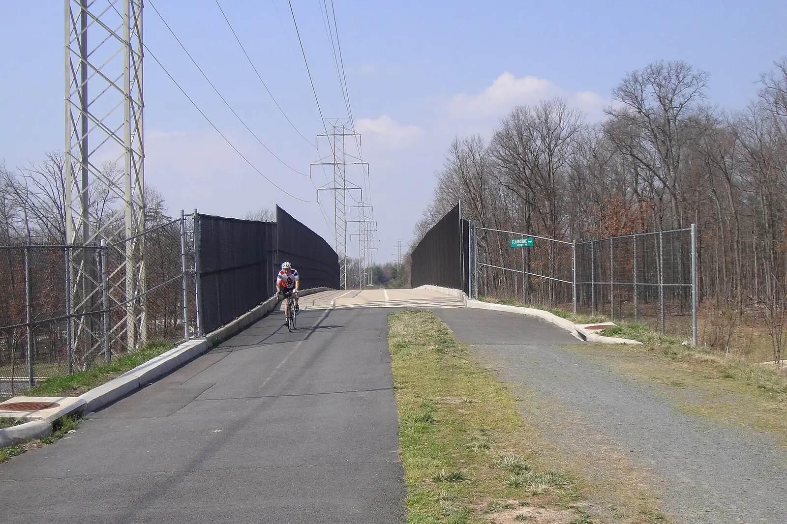
- The W&OD Trail, NOVA Parks’ paved 45-mile rail trail, crosses Claiborne Parkway on the bridge in the photo above. It is open 5 a.m. to 9 p.m. daily.
Ashburn Library, 43316 Hay Road, is about a quarter mile outside the community’s edge. See our parks and trails guide.
Getting around
Distances are measured on the road network from the middle of Ashburn Farm (OSRM routing on OpenStreetMap data). They are distances, not drive times.
| To | Distance |
|---|---|
| Dulles Greenway Exit 4 (Belmont Ridge Road) | about 1.3 miles |
| Dulles Greenway Exit 6 (Route 772) | about 2.1 miles |
| Ashburn Metro station (Silver Line) | about 5.0 miles |
| One Loudoun | about 5.2 miles |
| Washington Dulles International Airport | about 9.4 miles |
The Dulles Greenway is a toll road. Loudoun County Transit’s fare-free Routes 343 and 344 (Goose Creek Village/Ashburn Farm) stop at seven places inside the community and run to the Ashburn Metro station, according to the county’s GTFS schedule data. Route details are in our getting around guide.
Groceries and everyday stores
OpenStreetMap lists inside the community:
- Giant, 43330 Junction Plaza, with a Giant Pharmacy
- Patel Brothers
Close by, within about a mile and a half: Aldi, 43150 Broadlands Center Plaza; Lidl, 21285 Coopers Hawk Drive; Harris Teeter, 42780 Creek View Plaza; and Walgreens, 42820 Creek View Plaza.
How to check an address
Search the parcel on Loudoun County’s WebLogis map for zoning and the assessed value, then check the schools in LABEL. Real estate tax is billed by Loudoun County; see our property tax guide. All 10 areas are on our Ashburn neighborhoods guide.
Frequently asked questions
What high school is Ashburn Farm zoned for?
Stone Bridge High School, 43100 Hay Road. Every address in Ashburn Farm is in the Stone Bridge High and Trailside Middle zones for 2026-27, according to Loudoun County’s attendance zone map.
What elementary school serves Ashburn Farm?
It depends on the street. Of the county’s address points in Ashburn Farm, 44% are in the Cedar Lane Elementary zone, 37% in Sanders Corner Elementary and 20% in Belmont Station Elementary. Check one address in the LCPS LABEL lookup.
What ZIP code is Ashburn Farm in?
ZIP code 20147.
Is Ashburn Farm a good place to live?
That depends on the household. The facts: Ashburn Farm is a 1,173-acre planned community with 3,784 homes, two county parks, all zoned for Stone Bridge High, which is rated Distinguished by the state. Zillow’s typical value for ZIP 20147 was $746,114 in September 2026.
Have your say