Ten Ashburn-area neighborhoods compared: ZIP code, zoned high school and Zillow home value for each, from Ashburn Farm to Brambleton.
Last checked Oct. 19, 2026. Areas come from Loudoun County GIS (the Residential Communities, Village Conservation Overlay and planning layers), the county’s 2019 General Plan, U.S. Census Bureau place boundaries (TIGERweb) and OpenStreetMap place names (© OpenStreetMap contributors). School zones are the county’s 2026-27 attendance zone layers; home values are the Zillow Home Value Index (Zillow Research); population is the Census Bureau’s 2020-2024 American Community Survey.
Ashburn has no city limits. It is unincorporated, so Loudoun County is its local government, and “Ashburn” means two different things. The Census Bureau’s Ashburn census-designated place covers 15.3 square miles and 46,026 residents: Ashburn Farm, Ashburn Village, Old Ashburn, Potomac Green and the employment areas east to Route 28. The Postal Service’s Ashburn, ZIP codes 20147 and 20148, reaches much farther, into Belmont, One Loudoun, Broadlands, Brambleton, Moorefield Station and Loudoun Valley Estates, each of which the Census Bureau counts as a separate place.
Three highways frame the area. Route 7 runs along the northern edge toward Leesburg and Tysons. The Dulles Greenway, a toll road, cuts diagonally through the middle; ZIP 20147 is mostly north of it and 20148 mostly south. Route 28 marks the eastern side, and the Silver Line ends at the Ashburn Metro station in the Greenway median. School attendance zones follow none of these lines: Loudoun County Public Schools assigns by address, and several areas below are split.
What this means for you
- No town government: county offices handle permits, taxes and roads; see who to call in Loudoun County
- Schools go by address: check every address in the LCPS LABEL lookup
- Home values: Zillow’s typical Ashburn value was $795,910 in September 2026; ZIP 20147 was $746,114 and ZIP 20148 $869,300
Map of the areas
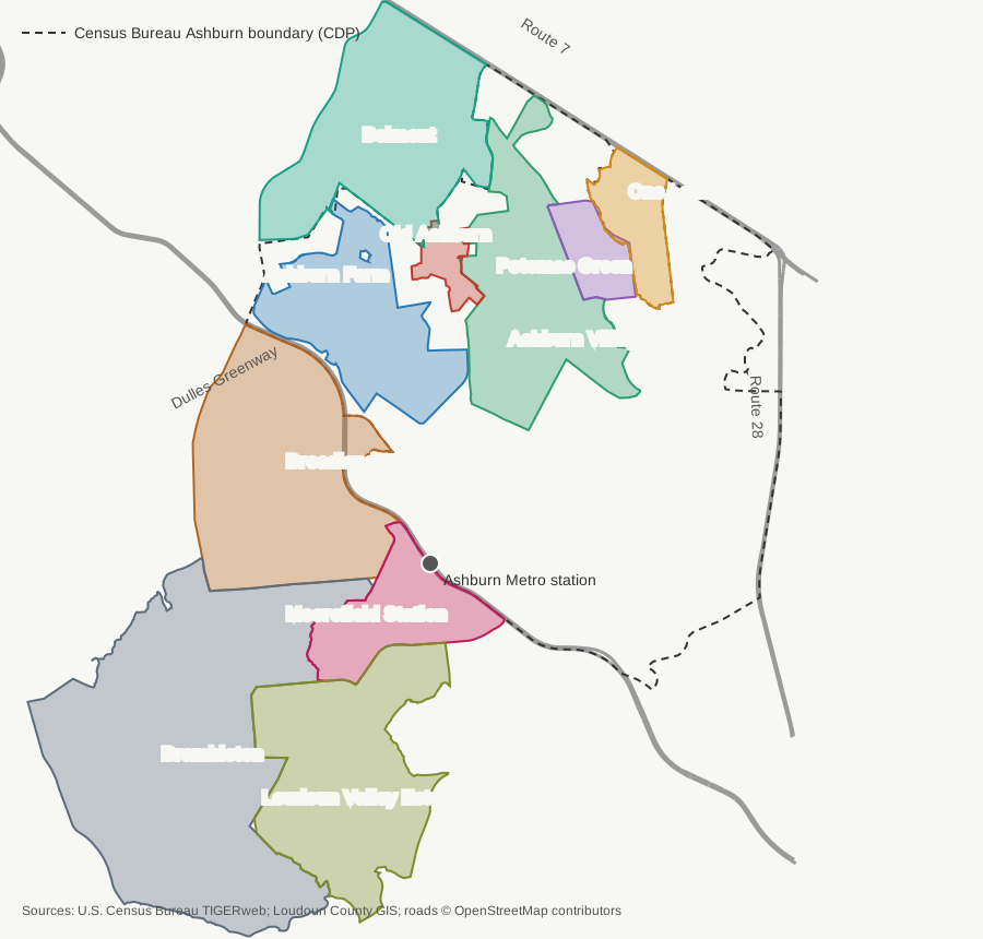
Map: Ashburn Today, from U.S. Census Bureau TIGERweb place boundaries, Loudoun County GIS community and overlay layers and road lines © OpenStreetMap contributors.
The 10 areas at a glance
| Area | ZIP code | Zoned high school (2026-27) | Typical home value in its ZIP, Sept. 2026 | Guide |
|---|---|---|---|---|
| Ashburn Farm | 20147 | Stone Bridge | $746,114 | Ashburn Farm |
| Ashburn Village | 20147 | Broad Run | $746,114 | Ashburn Village |
| Old Ashburn | 20147 | Stone Bridge (97%), Broad Run | $746,114 | Old Ashburn |
| Potomac Green | 20147 | Riverside | $746,114 | Potomac Green |
| One Loudoun | 20147 | Riverside | $746,114 | One Loudoun |
| Belmont | 20147 | Riverside (58%), Stone Bridge (43%) | $746,114 | Belmont |
| Broadlands | 20148 (95%), 20147 | Briar Woods | $869,300 | Broadlands |
| Brambleton | 20148 | Independence (69%), Briar Woods (20%), Rock Ridge (11%) | $869,300 | Brambleton |
| Moorefield Station | 20148 | Rock Ridge | $869,300 | Moorefield Station |
| Loudoun Valley Estates | 20148 (91%), 20166 | Rock Ridge | $869,300 | Loudoun Valley Estates |
Percentages are shares of Loudoun County’s address points in the area. Home values are Zillow’s Home Value Index for the ZIP code from its ZIP code file: a modeled typical value for mid-priced homes, not a sale price. Each ZIP covers several areas, so the figure is the same across them. More in our home prices guide and schools guide.
How many people live where
The Census Bureau’s 2020-2024 American Community Survey estimates, for the areas it counts as places:
| Census place | Residents | Households | Median home value |
|---|---|---|---|
| Ashburn | 46,026 | 17,513 | $699,300 |
| Brambleton | 24,537 | 7,961 | $865,800 |
| Broadlands | 14,353 | 4,479 | $896,900 |
| Loudoun Valley Estates | 10,271 | 3,463 | $814,200 |
| Belmont | 9,729 | 3,182 | $846,300 |
| Moorefield | 6,123 | 2,205 | $800,200 |
| One Loudoun | 3,309 | 1,113 | $876,700 |
Census home values are owners’ estimates from a survey, so they differ from Zillow’s. Our population guide has more on Ashburn’s growth.
North of the Greenway (ZIP 20147)
Ashburn Farm. A completed planned community of 3,784 homes on 1,173 acres along Ashburn Farm Parkway and Claiborne Parkway, zoned for Trailside Middle and Stone Bridge High. Ashburn Park and Greg Crittenden Memorial Park are inside it, and Greenway Exit 4 is about 1.3 miles away by road.
Ashburn Village. The largest completed community in the Census Bureau’s Ashburn, 5,075 homes on 1,484 acres along Ashburn Village Boulevard and Gloucester Parkway. Every address is zoned for Farmwell Station Middle and Broad Run High; Routes 341 and 342 run from it to the Metro station.
Old Ashburn. The 1860 railroad village on Ashburn Road where the W&OD Trail crosses it, now a 165-acre county conservation overlay district. The county’s General Plan limits new homes there to four an acre or fewer.
Potomac Green. An age-restricted community of 1,363 homes off Marblehead Drive, next to One Loudoun, zoned for Riverside High.
One Loudoun. The town center at Route 7 and Loudoun County Parkway, with 1,446 homes built and 1,718 more approved. Our separate One Loudoun guide covers the restaurants and events.
Belmont. The northwestern corner along Route 7, including Belmont Country Club and Belmont Greene, about 3,560 homes split between the Riverside and Stone Bridge high school zones.
South of the Greenway (ZIP 20148)
Broadlands. A planned community of 14,353 residents across the Greenway from Ashburn Farm, almost all zoned for Briar Woods High, with a nature center and four grocery and drug stores inside it.
Brambleton. The largest of the areas, 24,537 residents on 5.75 square miles, with six public schools, Brambleton Library and Reservoir Park on Beaverdam Reservoir. Its addresses split among three high school zones.
Moorefield Station. The new neighborhood beside the Ashburn Metro station, mostly townhouses and apartments, with 3,310 more homes approved. All of it is zoned for Rock Ridge High.
Loudoun Valley Estates. A completed community of 3,697 homes along Loudoun County Parkway south of Moorefield Station, zoned for Stone Hill Middle and Rock Ridge High, both inside it.
Getting around
Every area is served by Loudoun County Transit’s fare-free local buses to the Ashburn Metro station except Old Ashburn, which has stops about 0.4 miles away on Gloucester Parkway. Road distances, Greenway exits and routes are on each area’s page; the network is in our getting around guide, and current closures are in road construction and closures.
How we built this
- Which areas: We used areas a public source names and maps. Ashburn Farm, Ashburn Village and Potomac Green are communities in Loudoun County’s Residential Communities layer, and OpenStreetMap labels them with the same names. Old Ashburn is the Ashburn district of the county’s Village Conservation Overlay District, which the 2019 General Plan calls a “legacy village core.” Belmont, One Loudoun, Broadlands, Brambleton, Moorefield Station (the Census Bureau’s Moorefield) and Loudoun Valley Estates are Census Bureau places with Ashburn addresses.
- Left out: Lansdowne, which has Leesburg addresses, and smaller places such as Goose Creek Village. We did not write separate pages for individual subdivisions.
- School zones: We counted Loudoun County’s address points against the county’s 2026-27 elementary, middle and high school zone layers. The percentages are shares of addresses, not of students.
- No rankings: These pages report facts. We do not rate or rank areas.
Corrections: see our corrections policy.
Frequently asked questions
What are the neighborhoods in Ashburn, Virginia?
The main areas with Ashburn addresses are Ashburn Farm, Ashburn Village, Old Ashburn, Potomac Green, One Loudoun, Belmont, Broadlands, Brambleton, Moorefield Station and Loudoun Valley Estates. Loudoun County and the Census Bureau map each of them.
Is Brambleton part of Ashburn?
Brambleton has Ashburn mailing addresses in ZIP code 20148, but the Census Bureau counts it as its own place, with 24,537 residents. Ashburn and Brambleton are both unincorporated, so Loudoun County governs both.
What ZIP codes are in Ashburn, VA?
20147 and 20148. Broadly, 20147 covers the area north of the Dulles Greenway and 20148 the area south of it, including Broadlands, Brambleton, Moorefield Station and most of Loudoun Valley Estates.
Which high schools serve Ashburn neighborhoods?
Stone Bridge, Broad Run, Briar Woods, Independence and Rock Ridge, which have Ashburn addresses, and Riverside, which has a Leesburg address. Loudoun County Public Schools assigns by address, so check the LABEL lookup.
Does Ashburn have city limits?
No. Ashburn is unincorporated, so it has no city government or city limits. The Census Bureau draws an Ashburn census-designated place for statistics, and the Postal Service uses Ashburn for ZIP codes 20147 and 20148.
Have your say