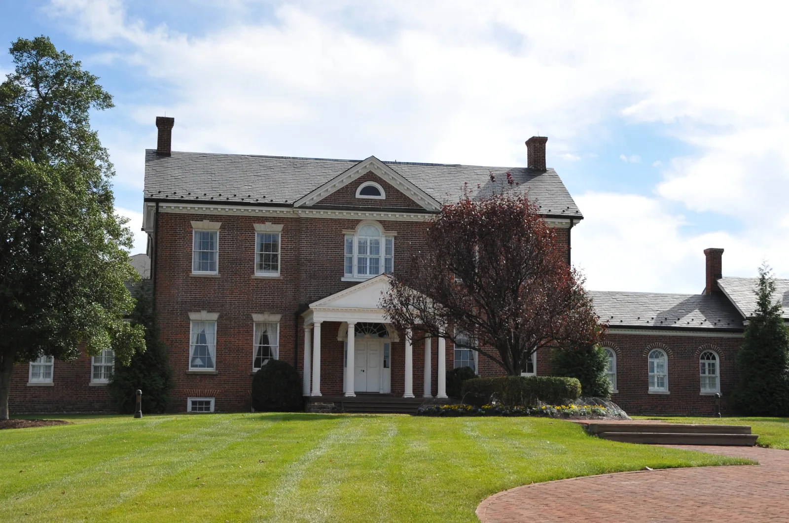
Belmont, along Route 7 north of Ashburn Farm, has 9,729 residents in ZIP 20147, split between the Riverside and Stone Bridge high school zones.
Last checked Oct. 19, 2026. The boundary is the U.S. Census Bureau’s Belmont census-designated place (TIGERweb); people and homes come from the Census Bureau’s 2020-2024 American Community Survey (data.census.gov) and Loudoun County’s Residential Communities layer (July 1, 2025); school zones are the county’s 2026-27 elementary, middle and high school zone layers, counted over the county’s address points; ratings are the Virginia Department of Education’s School Quality Profiles; home values are the Zillow Home Value Index (Zillow Research); buses are Loudoun County Transit’s GTFS feed (Sept. 27, 2026); parks, stores and road distances come from OpenStreetMap (© OpenStreetMap contributors).
Belmont is the northwestern corner of Ashburn, between Route 7 and Ashburn Farm, and the home of Belmont, the Lee family’s manor house from 1802. The Census Bureau counts it as its own place, the Belmont census-designated place: 2.7 square miles and 9,729 residents, outside the Census Bureau’s Ashburn boundary but with Ashburn addresses in ZIP code 20147. It is in the county’s Ashburn planning subarea.
What this means for you
- Zoned high school: split; about 58% Riverside High (Leesburg address) and 43% Stone Bridge High
- Typical home value, ZIP 20147: $746,114 in September 2026, according to Zillow; the Census median home value for Belmont is $846,300
- Nearest Dulles Greenway exit: Exit 4 (Belmont Ridge Road), about 3.3 miles by road; Route 7 runs along the northern edge
- School zone questions: LCPS Planning and GIS Services, 571-252-1050
Where it is
The Census place runs south from Route 7 to the W&OD Trail and Ashburn Farm, with Belmont Ridge Road along most of its western side and Ashburn Road on parts of its eastern side. Inside, the main roads are Gloucester Parkway, Claiborne Parkway, Portsmouth Boulevard and Belmont Ridge Road. Lansdowne, which has Leesburg addresses, is across Route 7 to the north; Old Ashburn and Ashburn Village are to the southeast. OpenStreetMap places the Belmont village name, the Belmont Country Club and Belmont Greene names inside it.
The Belmont manor house in the photo was built from 1799 to 1802 for Ludwell Lee, son of Richard Henry Lee, according to its Commons file; it was listed on the National Register of Historic Places in 1980. See our history and landmarks guide.
Homes and people
Loudoun County’s Residential Communities layer places these communities inside the Census place, as of July 1, 2025:
| Community | Single-family | Townhouses | Condos and apartments |
|---|---|---|---|
| Belmont Country Club | 886 | 844 | 198 |
| Belmont Greene | 482 | 318 | 0 |
| Smaller communities, combined | 453 | 184 | 194 |
| Total | 1,821 | 1,346 | 392 |
That is about 3,560 homes, with 111 more approved at Belmont Park. The Census Bureau’s 2020-2024 American Community Survey counts 3,182 households, 2,783 of them, or 87%, in owner-occupied homes. The median home value estimate is $846,300.
Schools
Belmont is split between zones. Of the 3,541 county address points in the Census place, for 2026-27:
| School | Grades | Address | Share of addresses | State rating |
|---|---|---|---|---|
| Newton-Lee Elementary | K-5 | 43335 Gloucester Parkway | 75% | Meets Expectations |
| Belmont Station Elementary | K-5 | 20235 Nightwatch St. | 25% | Distinguished |
| Belmont Ridge Middle | 6-8 | 19045 Upper Belmont Place, Leesburg | 58% | Fully Accredited |
| Trailside Middle | 6-8 | 20325 Claiborne Parkway | 43% | Distinguished |
| Riverside High | 9-12 | 19019 Upper Belmont Place, Leesburg | 58% | Fully Accredited |
| Stone Bridge High | 9-12 | 43100 Hay Road | 43% | Distinguished |
Newton-Lee, Belmont Station and Trailside Middle are inside the Census place. The rating is the school’s level in Virginia’s School Performance and Support Framework; Belmont Ridge and Riverside, with Leesburg addresses, are shown as Fully Accredited for 2025-26, as are all the others. The middle and high school lines run together, so a street zoned for Belmont Ridge goes on to Riverside. Check one address in the LCPS LABEL lookup and see our schools guide.
Home values
Zillow’s Home Value Index for ZIP 20147 was $746,114 in September 2026, up 0.9% from $739,759 in September 2025, according to Zillow’s ZIP code file. Zillow’s figure for all of Ashburn was $795,910, up 0.5%. Zillow publishes no figure for Belmont alone. The index is a modeled typical value, not a sale price. See our home prices guide.
Parks and trails
- Beth Miller Park, 20270 Leier Place, inside the Census place, as mapped on OpenStreetMap.
- Trailside Park, 20375 Claiborne Parkway, just past the southern edge: 20 acres on the W&OD Trail with a softball complex, inline hockey, batting cages and a playground.
- The W&OD Trail runs along the southern side. It crosses Belmont Ridge Road at street level, so watch for traffic.
See our parks and trails guide.
Getting around
Distances are measured on the road network from the middle of the Census place (OSRM routing on OpenStreetMap data); they are not drive times.
| To | Distance |
|---|---|
| Dulles Greenway Exit 4 (Belmont Ridge Road) | about 3.3 miles |
| One Loudoun | about 3.4 miles |
| Ashburn Metro station (Silver Line) | about 6.9 miles |
| Washington Dulles International Airport | about 11.3 miles |
Loudoun County Transit’s GTFS data show a few stops inside Belmont on the fare-free Ashburn Village routes, 341 and 342, and the Ashburn Farm routes, 343 and 344, all running to the Ashburn Metro station. See our getting around guide.
Groceries and everyday stores
OpenStreetMap lists Whole Foods Market, 19800 Belmont Chase Drive, inside the Census place. Close by: Walgreens, 20321 Susan Leslie Drive; Harris Teeter, 19350 Winmeade Drive; and CVS Pharmacy, 19305 Ruby Drive.
How to check an address
Search the parcel on Loudoun County’s WebLogis map for zoning and the assessed value, then check the schools in LABEL. Real estate tax is billed by Loudoun County; see our property tax guide. All 10 areas are on our Ashburn neighborhoods guide.
Frequently asked questions
What high school is Belmont in Ashburn zoned for?
It is split. For 2026-27, about 58% of the county’s address points in the Belmont Census place are zoned for Belmont Ridge Middle and Riverside High, and about 43% for Trailside Middle and Stone Bridge High. Check one address in the LCPS LABEL lookup.
What communities are in Belmont?
Loudoun County’s residential communities data place Belmont Country Club (1,928 homes), Belmont Greene (800) and several smaller communities inside the Belmont Census place, about 3,560 homes in all.
How many people live in Belmont, Virginia?
9,729, according to the Census Bureau’s 2020-2024 American Community Survey estimate for the Belmont census-designated place.
Is Belmont in Ashburn a good place to live?
That depends on the household. The facts: Belmont is a 2.7-square-mile Census place in ZIP 20147 with three public schools inside it, a Whole Foods Market and the W&OD Trail nearby. The Census median home value was $846,300, and Zillow’s typical value for ZIP 20147 was $746,114 in September 2026.
Have your say